You won’t find any new filters in the latest version of Instagram. Instead, the fourteen person team behind the world’s most beloved mobile app (now 80 million registered users strong) has decided to think outside the box, the browser box. “With every dot oh release we’ve tried to shift our focus dramatically,” Instagram CEO Kevin Systrom tells me in one of the longest interviews I’ve ever conducted about a UI change , “Instagram 2.0, with its new filters, etc, was all about the user’s production experience. Instagram 3.0 is about a new kind of browser experience, Photo Maps.”
 Almost like Instagram’s mobile-focused answer to Facebook’s Timeline, Photo Maps — available on both iOS and Android — is an attempt to provide narrative around the photos users have up until now uploaded with no real structure.
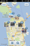
Location data is used to create custom map of photos (hence the name), allowing users to tell more coherent stories about photos they’ve been uploading willy nilly. The feature will initially pull in photos from the past that you’ve added a location to, which you probably didn’t think twice about.
“We’re constantly knocking these bits of information into social media — It’s too ephemeral,” Systrom says, who believes that location data is the most effective way to organize activity for mobile.
He calls the step a foray into making geo-location a first class citizen inside Instagram., “How many times have you gone to a user profile and scrolled back to the beginning? No one does. This is a way to take a step back and reflect on everything that’s happened over the past two years. “Photo Maps is such a fun way of re-descovering yourself, but not just yourself, all Instagram users.”
Users who download the new app after the update will see a Photo Map section on their profiles, in addition to the standard Grid and Chronological profile view. When you navigate through that you’ll get an option to see all photos you’ve geo-tagged in the past.
Users can then edit out the photos they don’t want to include on their map, review their final selections and hit ‘Done.’ Once you’re done editing, images in a given location group will form a pile/stack on your Photo Map. Geolocation data will be removed from the ones you deselect.
You can browse other maps by selecting the Photo Map option on a given user’s profile, and tap into any photo stack in order to drill down into a given location. Double tapping a stack allows you to view the stack in a grid format.
By giving so much weight to geolocation in the browsing experience, Instagram is giving a big vote to the somewhat under-utilized piece of data. “Instagram is definitely still about quick updates on the go,” Systrom says, “But we  also want to give you a different lens. We realized that chronological order was not the way we wanted you to browse overall, and we decided that location was more important.”
Systrom tells me that the feature has evoked a sort of nostalgia in user testing. “We’ve had people who moved here from Belgium going back and looking at photos from home and remembering a different time.” “Location is a new dimension, he says, “Viewing photos is not just about the ephemeral nature of snapshots, it’s about going back into your bedroom and opening your shoeboxes.”
Because not everyone yet is comfortable with sharing their whereabouts, past or present, Systrom emphasizes that users will be able to heavily edit what photos they chose to add to Photo Map. “We’re not introducing any new data,” he says, “All this stuff is already public. I’m able to deselect my house and my parents. And the whole goal here is to make it easy for people to show what they want to show.”
In addition to Photo Maps, the new version of Instagram includes many minor UI improvements including multi-line caption editing, more streamlined photo uploading, speed improvements and infinite scroll. Because Instagram has had very noticeable issues with spam as it scales, Systrom has introduced a way to mark any comment, yours or otherwise, as spam. Also notable is that the Twitter “Find Friends” feature is missing, after Twitter shut off its API to the company late last month.
Though Systrom tells me that acquirer Facebook’s overall product strategy had no effect on these UI changes, the feature is definitely an early sign of Instagram’s new direction, “I think we’ve built the best version of the social photo map,” Systrom says, implying that the startup, which still has yet to be integrated into Facebook, is setting the stage for something larger like having photos flow into geodata.
Just as Josh Constine predicted in this post and MG Siegler foreshadowed in this one, Systrom wants you to be able to use Instagram to hone in on specific locations, “I want to tune into the London Olympics, or Burning Man by using location the same way you explore via hashtags or via a profile,” Systrom says. He predicts that in the long run the company will be building on top of the location layer. “We eventually want 100% of photos to be geo-tagged,” he says, hoping the feature will eventually allow Instagram to become “a backstage pass into anywhere in the world.”
You can download the new update once it goes live here.